Finishing up maps today and do a print out to view them on paper -
Meeting with Matt and Drew to go over the maps-
Adding in:
a. Neatline
b. Legend
c. Scale
d. North Arrow
*in order to edit the legend to be as you want - go into 'style' under 'legend items' (added description and legend title)
Not adding in neatline, legend, etc. Drew is doing that in photoshop
_____________
When sending data to Drew add both a River/Lakes map as well as one without.
_____
1. Added in all of the islands to the layers
2. Fixed the Smoothed St. John River to match up with outline of Maine - split the features of a copy of the state along with the smoothed river and merged the two together.
3. Save and send copies.
Wednesday, May 12, 2010
Tuesday, May 11, 2010
Acid Rain - projection
The data was sent by Eric over the weekend - different data set
Opened the data into blank arcmap -
1. tool box
a. data management
b. projections and transformations
c. raster
d. project raster
Input Coordinate System - Albert's Equal Area conic for EPA (suggests that projection has been found in original data)
Output - NAD1983, UTM 19
Eric mentioned that we should use 'Nearest Neighbor' and this option was preselected.
----
Created Raster - converting image over to polygon - still a lot of data to try and manage
______
Exported Map into Photoshop as .TIF
Used Magic wand to select gray color
Under 'Select' option -'Modify' - 'Expand' - '2 pixels'
Deselected Anti-Aliased and Contiguous to remove gray boarder - however the smoothed option creates a different impression of acid rain in Maine than compared to the original.
_____
States and Provinces:
Exported out data for States and Provinces (minus Maine in the 'States' data)
Created new features along the boundaries merged two pieces together
Clipped the features to the state of Maine (make sure to select 'discard' area that intersects)
Grayed and Whitened the areas/boundaries
Friday, May 7, 2010
Acid Rain
Having issues with trying to create Acid Rain map -
Matt called Eric Miller (Ecosystems Research Group, Inc.) - data is being sent in another format - hopefully we can convert the data (Idrisi) easily into ARCMap.
New data will be produced in about three weeks to have updated data of acid rain sensitivity for 2018 (based on pollution control measure already researched).
Saturday, April 24, 2010
Cutting Polygons
Finished conservation land piece
Started work on biophysical regions
Getting better at using the arctool in the editor toolbox
Figured out why the clipping was acting weird - I had the preservation set wrong
However, the clip feature only clips the and in Maine not all the little islands and anytime I would select all to clip - the option was no longer there - so still having a little trouble with that piece.
Thursday, April 22, 2010
Earth Day!
Worked on some georeferencing - Drew stopped by and gave me an AcidRain file to georeference.
Showed Drew some of the maps - we saved the base map as a TIF as 600 resolution - if I want to show more for him to label (he'll do labeling in photoshop) save map at 72.
Ran into a clip problem - I followed my previous directions for clipping a new polygon to MaineSmooth but I was not detailed enough and have a problem with the polygon clipping but then keeping the initial box around the state of Maine.
Work some more tomorrow.
Wednesday, April 21, 2010
Images


Two print screens of maps so far to give an idea (different colors for final) one of glacial retreat (top) and the other is the intersection of plant boundaries (bottom)
Tomorrow will start work on Figure 5.14A from Illustrations document.
Friday, April 9, 2010
Issues
Went back to try and fix the general idea of how the ice sheet map would look:
Any time I tried to add in a vertex the auto-complete would create gaps (which I sort of expected but was hoping would not happen) and I couldn't move any of the vertices without moving the whole map -
Have gone through and am now re-doing the outline of glaciation but sometimes the auto-complete doesn't want to capture the sketch and I have to re-do my work again...frustrating...
________
Cut out the polygons at the top of AR county - but still cannot get one of them to show.
Georeferenced one part of the vegetation trend piece and cut out one of the paths.
Thursday, April 8, 2010
Email from Drew
Notes from Email: (think about working on tomorrow as well as digitizing maps)
1. Roads are not necessary (clean-up)
2. Add in Mt. Katahdin (figure out how to label that)
3. Major cities are not necessary for seven individual maps - but should be added into the full-page map:
Portland Bangor
Augusta Presque Isle
Greenville Eastport
Ellsworth Farmington (maybe)
As well as maybe adding some labels into the major islands such as MDI
Wednesday, April 7, 2010
What else to add?
Met with Drew and Matt today to look over the map:
What else needs to be added to the initial maps?
Mtns?
Additional Data:
Digitizing Maps
Biophysical Map - Maine Forest Service
Bangor, Augusta, Portland, Maybe LA and Presque Isle
Georeferencing:
a. Turn image into JPEG (copy from word into photoshop)
b. Add data
c. Open tool bar - georeferencing
d. Fit to display (click once)
e. Make sure the right layer is showing in options
f. 'Add Control Points' (little green and red x's)
g. Update Display (to lock and make sure the changes are made - but don't hit fit to display again)
h. Update Georeferencing
Create New Layer in Catalog - MaineIceSheet
Add Data to the Map - start editing out different ice sheet layers
1. make first polygon
2. auto-complete successive polygons
3. doughnut shapes (AR county) - different step go to help to figure out
4. smooth Maine boundary to clip the ice sheet polygons
For Friday:
Use either the pencil or curve option to select out each of the polygons -
Only select the MaineSmooth layer (but still have the editor on the MaineIceSheet layer) -
Go into the options and clip the layer which will bring together each of the new polygons to the MaineSmooth layer.
Use the Cut Polygon Features option to select out the other layers
(Add numbers 0,1,2, etc. in the attribute table to create the gray scale)
Wednesday, March 31, 2010
Print, Annotation, Export
Printed a version of the map - the coast is looking better but the roads look sloppy as well as the labels for rivers/lakes.
- Need to export all of the rivers into one file
- Exported data to individual folders to keep everything better organized so that multiple files, smoothing files, etc. can be deleted from the Ddrive and it is insursed that the data will be there through exporting.
- Text cannot be linked to a layer -
- When applying labels in the layer there is no 'name' assignment
a. Open Attribute Table
b. Add Field
c. Turn on Editor
e. Select each of the lakes and type in 'name'
f. Apply Labels (Label Feature)
g. Go into Properties - labels
h. select 'lake names'
!
Convert labels into annotations using ARCGIS help option - main advantage is scale and individual control over annotations.
To turn Annotations 'on' and 'off' go to
a. View
b. Data Frame properties
c. Annotations Groups - tab
d. deselect the annotations
Converted Rivers into annotations using the same steps - annotation overflow was an error and use ARGGIS help option to add the annotation
- for whatever reason Saco River was not included in annotation process - ?
Re-did the label-annotation process - St. John and Allagash were deleted - we think all the rivers need to be in the screen view in order to have the annotations apply (strange) so I zoomed out of the map a little and tried for a third time (while also turning off the roads layer to try and 'give' more room for the labels) and this time all annotations are on the map as well as no having any problem with overflow.
Questions:
- Where is the rest of the Androscoggin (NH?
- Do we want the other lakes in the general vacinity of Richardson Lake?
- Will Annotations work better than labels?
- Roads look awkward - do we still want them?
Wednesday, March 24, 2010
Clean up - Labels v. Annotation v. Text
Cleaned up the lakes layer - initially we went into the properties menu, selected quantities, and created two natural breaks in the Lake Layer - area greater than 14000 acres and area less than 14000. The areas less than were deemed too small for what we are trying to accomplish and we made the feature hollow with no outline to 'hide' the feature.
Unfortunately when we figured out smoothing the coast the lakes layer needed to be above the state outline (to show up on the map) but there were all these little white marks from where the lakes had previously been.
Today I found the smallest area for the lake we were using (using the identify tool) and selected out the features that were less than 14000 acres and deleted them using the 'Select by attribute feature'
Questions:
Friday, March 19, 2010
Labeling
Working on labeling the rivers, lakes, and roads
Commands:
View - toolbar - labeling
*Reading on ArcGIS to try and figure out with method is better - adding a text and then spiraling might work better than trying to apply labels - it seems (knowledge found through online text) that you can only add labels to one area and need to create annotations - not sure which method is better (Ask Matt) but for now adding text seems to be going better for me.
TEXT is found at the bottom (of at least our version) and is displayed through the DRAW toolbar - use the Spiral Text Option to get the text to curve around the River
To Edit vertex use the Edit button (Text must be selected when using this option) next to the text option and start shifting things around
When it comes to labeling it really helps having the rivers smoothed
___________________________
Since the text is not saved as a layer the text size changes depending on the zoom which makes for a messy/interesting map...
Can text be made into a layer? or file? or something?
Next meeting:
Wednesday at 1pm - annotation v. labeling v. text - where to go next - how to make text align better...etc. 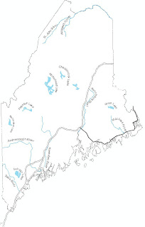
Still needs work but gives an idea of smoothed coast as well as labels (roughly).Friday, March 12, 2010
Maine
- Began merging all the towns/ships in Maine which worked better today (Wednesday the computer would not respond when I tried to merge...) - there are some little gaps (including Moosehead Lake) which I am merging to Maine polygon so that when we simplify everything will be all one piece.
(side note - did end up smoothing the rivers after merging the pieces we wanted)
*Drew wants the initial map to include surrounding territories and then all of the other maps to be just of Maine.
- When smoothing the coast of Maine - Beizer does not work (creates an error OS) and Pake will only work if you tell the smoothing to Flag Errors
- Cut out the coast from Maine (using Cut Feature in Editor), exported that data into MaineCoast and smoothed it at 5000m - Made a Copy of the initial file we cut from and merged the two together - State looks a lot better than when we started.
- Added in what was thought to be major roads (MetaData said roads that posted above 40mph where in the file) but does not include I95 or 295...E911 is a dense set of data and could get messy when trying to select out and edit major roads.
- Looking for data on the whole country - found US Interstate Highway Data from NOAA and need to change the projection - data at the country level will (hopefully) be easier to work with.
- Needed to change the projection (datamanagment - projections and transformations - raster- define projection) and then fit it to Maine's UTM (data - projections - feature - project)
- Selected out (using the identify tool since names have changed after the file was create) roads wanted!
Roads - what symbols to use?
Rivers - same
Shaded Relief
Other states
Coastline
Labels - how should everything be labeled (Annotation, layer?)
Symbolizing terrain/mountains
Lakes (select out major lakes and export them to a different file? - creates weird gaps on the boarder)
Wednesday, March 10, 2010
Smooth?
Trying to smooth out the coast of Maine by taking a polygon (selecting out the islands) and converting it to a line feature -
Matt also tried calling the Community for GIS in Farmington to see if they had any advise but no one was there
So far having a little trouble with selecting out the islands and getting them to delete
Created a New Field called 'Acres', calculated the geometry and then selected features that were less than 2500 acres - the areas are selected but when I try to delete it does not seem to want to ________
Dear Sarah,
You need to turn on the editor tool to delete...
______________________________
Deleted out hydro features less than 2500 acres and the coast line is starting to look better - going to try and smooth the polygon (even though we were having trouble before) rather than make it a line because maybe with the little islands gone, the smoothing will go better - did not go according to plan -
Meet again on Friday.
Friday, March 5, 2010
Meeting
Meeting with Matt and Drew today - finished rivers and lakes
Looking for shaded relief - ARCMap seems to have the data but unsure if we can edit.
ARCGis Online Resource Center
Talked about aesthetics and what to have on the map -
Looking for shaded relief - ARCMap seems to have the data but unsure if we can edit.
ARCGis Online Resource Center
Talked about aesthetics and what to have on the map -
Thursday, March 4, 2010
Rivers cont.
Finished Saco, St.John, and Andro - all rivers simplified.
Had the idea - if I am able to smooth the line feature of the State of Maine to be as I want - can I just convert that into a polygon rather than going through trying to smooth a polygon that doesn't seem to want to be smoothed?
Had the idea - if I am able to smooth the line feature of the State of Maine to be as I want - can I just convert that into a polygon rather than going through trying to smooth a polygon that doesn't seem to want to be smoothed?
Wednesday, March 3, 2010
Editing Rivers
Creating Single Lines
Open editor
select the features I want to use as the river
Use 'options' - 'switch selection' - delete
Now I can go through and select all the other features and delete - can use the split tool to make the shape into one line.
Snap all the pieces together and then merge the river to create one line.
*use shift to select all pieces needed
*might want to smooth the river a little before selecting out the features to delete.
Completed:
Penob
Kenn
Allagash
Machias
Monday, March 1, 2010
Rivers
Selected out parts of the Kennebec and created a line feature- created two lines rather than one
Commands
(Data management - features - polygon to line)
(data - generalization - smooth line)
Smooth - trying to smooth the lines of the river and is starting to work but still have two 'lines'
(use smooth rather than simplify) rather than being generalized into one
Collapse - tried at 1km to collapse the two outer lines together and then again at 5km and did not seem to make a difference
*for 'banks' topological error
Creating single line river is more complicated than expected - will work on this again Wednesday.
Friday, February 12, 2010
Maine
 Started simplifying the rivers by de-selecting the streams (I know there is another branch that Drew wanted that branches east of St. John but I do not know what it's called) but all of the rivers are there as well as the lakes (I believe that's Grand Lake - I downloaded the data and tried to find a clear map of where it is and I believe that's it).
Starting to come together?
Thursday, February 11, 2010
License Error
Upon opening ArcMap:
Prove your license server administrator with the following information:
Cannot connect to license server system.
The license server manager (lmgrd) has not been started yet,
the work port@hose or license file is being used, or theport or hostname in the license file has been changed.
Feature: ARC/INFO
Server name: mamdo.umf.maine.edu
License path: @mambo.umf.maine.edu;
FLEXnet Licensing error: -15, 570
Don't really know what that means but hopefully we'll be able to figure out something soon -
Mostly looking on MEGIS to try and find data that will be of use to create a shaded relief map.
Also downloading data to create a lakes/rivers map to have as the main inset map.
Meeting with Drew today and Matt tomorrow - hopefully this error will go away by then.
Found this website:
http://www.shadedrelief.com/planimetric/plan.html
- might help in making better shaded relief maps
Rivers:
St. John
Machias
Kenn
Penob
Pisca
Andro
Saco
York (?)
Lakes:
Moose
Flagstaff
Sebago
Grand Lake
Friday, February 5, 2010
Maps
- Started working on map of Maine -
- Created a line feature of Maine and was able to smooth the edges, especially around the coast
- Tried again with the polygon but have had no luck so far but managed to merge the townships together
- I used a simplify features and that seemed like it was going to be promising since I was able to set limits on area (which I thought would help with all the little islands) but it just made this awful jagged Maine esque state
- Added in Rivers - the map looks over crowded because there are so many so I think I'll have to go through and pick out which data sets I want...
Start work on shaded relief
See if I can smooth the coast better
Trial and error features
Subscribe to:
Posts (Atom)